


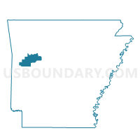
Barber Voting District, Logan County, Arkansas
About
Outline

Summary
| Unique Area Identifier | 527150 |
| Name | Barber Voting District |
| County | Logan County |
| State | Arkansas |
| Area (square miles) | 16.33 |
| Land Area (square miles) | 16.14 |
| Water Area (square miles) | 0.19 |
| % of Land Area | 98.85 |
| % of Water Area | 1.15 |
| Latitude of the Internal Point | 35.11816550 |
| Longtitude of the Internal Point | -94.09814760 |
Maps


Graphs
Select a template below for downloading or customizing gragh for Barber Voting District, Logan County, Arkansas


Neighbors
Neighoring Voting District (by Name) Neighboring Voting District on the Map
- Voting District 9-1-Q, Sebastian County, AR
- Voting District 9-2-E, Sebastian County, AR
- Voting District 9-3-G, Sebastian County, AR
- Boone Ward 4, Logan County, AR
- Cauthron Voting District, Logan County, AR
- Tomlinson Voting District, Logan County, AR
Top 10 Neighboring County Subdivision (by Population) Neighboring County Subdivision on the Map
- Boone township, Logan County, AR (5,721)
- Dayton township, Sebastian County, AR (731)
- White Oak township, Sebastian County, AR (608)
- Washburn township, Sebastian County, AR (487)
- Barber township, Logan County, AR (380)
- Cauthron township, Logan County, AR (365)
- Tomlinson township, Logan County, AR (325)
Top 10 Neighboring Unified School District (by Population) Neighboring Unified School District on the Map
- Greenwood School District, AR (19,838)
- Booneville School District, AR (8,038)
- Mansfield School District, AR (5,565)
Top 10 Neighboring State Legislative District Lower Chamber (by Population) Neighboring State Legislative District Lower Chamber on the Map
- State House District 67, AR (30,060)
- State House District 62, AR (27,262)
- State House District 84, AR (25,531)